Charles Fleming's book "Secret Stairs" was my introduction to urban hiking. His Mt. Washington walk, the fourth one I tackled, was the one that made me realize how little I knew about Los Angeles. As I climbed the hills and marveled at the views I found it hard to believe I was in a city, let alone a major metropolis. That was over ten years ago and I've continued to explore my surroundings on foot; always discovering new things. On a recent walk
Bob Inman took us to Rainbow Canyon, a new-to-me trail in the Mt. Washington area. It was the inspiration for this route that will introduce you to many of the trails and dirt roads scattered throughout the neighborhood. Unlike many of my other walks, this route is not stair-centric and doesn't go out of its way to appreciate any local architecture.
Despite the fact that the route is entirely within the city limits, this is more of a hike than a walk. Some of the trails are steep and can be slippery. Good hiking shoes and a walking pole are recommended. Bring plenty of water and a snack. There's nowhere to buy food along the way.
Before you go - This is a challenging 7.5 mile hike with a total elevation gain of approximately 1400 ft.
The route starts at the Heritage Square A line station and ends at the Southwest Museum station. If you drive to the start be sure to bring a TAP card to get back. There is parking at the start station.
There are no restrooms at the start. The Carlin G. Smith Rec Center has a restroom on the lower floor. It's closed on Sundays and sporadically closed other days. There is also a restroom at the Self-Realization Fellowship Headquarters; closed Mondays. It's just inside the entrance on the left around the back of the round building. They have always been very nice about letting hikers use it. Along the route, you may also stumble upon a porta-potty or two
Some of the turns are easy to miss. The following pictures will give you an idea of what to look for.
The first stairway is about half a mile in. Look for the mailbox on the left at 408 Beech St. The last time I was there it was quite overgrown. It might feel like you're on private property. Rest assured, it is a public right of way.
About half way up the Kite Hill trail you will come to a fork. Take the trail on the right that goes down. You're welcome.
The Rainbow Canyon trail was overgrown on my last visit. If I hadn't known it was there I never would have found it. Shortly after making a sharp right onto W. Ave. 44 look for it on the left. It kind of zigzags a bit down to W. Ave 45. It's short so even if it happens to disappear towards the middle you should be able to find the exit.
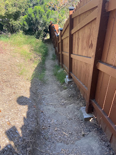
The trail to the Carlin G. Smith Rec Center was also overgrown on my last visit. Go down the stairs and turn right. Stay in the center of the ravine. The trail will start to climb after a bit. When you reach the fence make a sharp right. At the end of the fence make a sharp left. Turn right on the left side of the basketball court. The rec center is a good place for a mid-walk rest.
The entrance to Elyria Canyon Park is well marked. Once on the trail keep right at the bench and at second fork. At the next fork keep right.
At the end of San Andreas Ave. you'll find this short, extremely steep scramble up to the Sea View trail. This is where a hiking pole really comes in handy.
The Mavis Dr. stairway/trail is also easy to miss. Look for it on the left just after the mailbox at 340. Google maps incorrectly has a stairway a little further down the street. Don't take that one or you'll wind up at someone's front door.
The Mavis stairway starts out with stairs, becomes a dirt path, then a stairway again at the bottom.
You may come across a few signs like this. Ignore them. They are directed at cars.
I have not spotted any kitties in the area recently, but I once got a glimpse of this P22 impersonator so, as always, keep an eye out for felines.


Comments
Post a Comment