Posts

Showing posts from February, 2022

Sierra Madre

Image
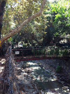
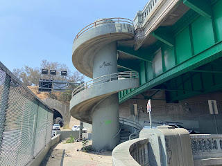
Sierra Madre We have the good fortune to live close enough to what may be the most charming city of the San Gabriel Valley to be able to walk there at least once a week. It's a unique urban hike that, if you're lucky, may include multiple wildlife sightings. We've seen deer, bobcats, and even a couple bears. Even if you don't see any wild animals you'll likely see two domesticated tortoises and many cats. We see one friendly cat so often that I've included him on my map. If you go in the morning you can have breakfast or lunch at Mary's Market in the heart of the canyon. Towards the end of the walk be sure to stop at E. Waldo Ward & Son to pick up a jar of preserves from this 100 plus year old business. Map of Sierra Madre Before you go -  The first part of the walk is challenging with many hills in the first 3 miles. The remainder is mostly flat. ❗The route includes a ladder (see photo below). Sometimes after a storm in may be lying on the ground and yo

Historic Core of Los Angeles

Image
Downtown's Historic Core includes the Old Bank District, Gallery Row, the Broadway Theater District, and the Jewelry District. This short 3.5 mile walk touches all of them. The landmarks highlighted on my map are just a fraction of the things to see along the route. This is a walk I would take people from out of town on.   Before you go - The route is a loop that starts and ends at the Pershing Square metro stop. If you're coming in by car you can start wherever you can find parking.  There is an easily accessible restroom at Grand Central Market and of course plenty of places to get food along the route.  You probably won't see any cats on this walk. Grand Central Market has many food choices but can be very crowded. The murals of Indian Alley can only be admired from the other side of the fence. There may be times when it's open but I don't know when that would be. The south end of the walk is technically not part of the Historic Core. It is just too good to leave

Atwater Village

Image
Atwater Village Strolling around Atwater Village on a sunny day is like a mini-vacation without leaving the city. This walk crosses three pedestrian bridges over the Los Angeles river and meanders through the charming bungalow lined neighborhood streets. There are many choices along the way for food and drink. La Villa Cafe on Chevy Chase is a good mid-way stop with outdoor seating. If you want to wait until the end of the walk head over to Lupita's Tamales on San Fernando. Get a few to go then bring them just up the street to Eagle Rock Brewery to enjoy with a beer or two. https://www.google.com/maps/d/u/0/edit?mid=1pgB2uL5-pl0mj1JxF7Bybp2BzTu5egH-&usp=sharing Before you go - The 7 mile route is mostly flat. The only challenge is the distance.  After crossing the Sunnynook Pedestrian Bridge back to the Atwater side of the river resist the urge to turn left to follow the river. Instead turn right and take the path down to Sunnynook Dr.  For a restroom at the start you'll ha

Two Spirals

Image
Two Spirals One of L.A.'s most unique pedestrian facilities can be found, in all places, on the 110 freeway just as it enters Chinatown. Commuters drive past the massive spiral staircase that connects the two 110 'sidewalks' daily, sometimes for years, without knowing any of it is there. Lifelong L.A. residents will exclaim, "I had no idea this existed!' when you show it to them. I've incorporated it into this route that also includes a pedestrian overhead crossing that is accessed on the Chinatown side by a spiral ramp.   Before you go - This 4.5 mile route is mostly flat with three up stairways including one of the spirals. Walking between two freeways in an enclosed are is a bit daunting. I don't recommend doing this walk after dark or alone.  There are clean restrooms in the parks at the start and at the 3.5 mile point. Street parking is usually available. You could also get there on the Metro L (gold) line. Get off at the Chinatown stop and start the w